Coverage Trajectory Generation
The xiao_hei_vln.trajectory module generates offline coverage trajectories
for CMU VLN Challenge scenes. Given a scene's traversable area and object list,
it produces an ordered list of waypoints that maximizes object and floor
visibility.
Pipeline overview
graph LR
    PLY[traversable_area.ply] --> POLY[Concave Hull]
    OBJ[object_list.txt] --> COV
    POLY --> ERODE[Erode by robot radius]
    ERODE --> GRID[Sample candidate grid]
    GRID --> COV[Coverage + 2D Raycasting]
    COV --> GSC[Greedy Set Cover]
    GSC --> VIS[Visibility Graph]
    VIS --> TSP[TSP Ordering]
    TSP --> ROUTE[Collision-Free Routing]
    ROUTE --> SC[Shortcutting]
    SC --> WP[Waypoints + Headings]
Quick start
Process a single scene:
Process all scenes in batch:
CLI options
| Flag | Default | Description |
|---|---|---|
--coverage-radius |
3.0 |
Object/floor visibility radius (meters) |
--robot-radius |
0.3 |
Polygon erosion for safe waypoint placement |
--grid-resolution |
0.25 |
Candidate viewpoint grid spacing (meters) |
--hull-ratio |
0.1 |
Concave hull tightness (lower = tighter) |
--out |
trajectories |
Output directory |
Algorithm
1. Polygon construction
The traversable area point cloud is converted to a 2D polygon using
shapely.concave_hull(ratio=0.1, allow_holes=True). Holes in the surface
correspond to furniture and obstacles. The polygon is then eroded inward by
the robot radius (0.3m) to ensure waypoints are safely reachable.
2. Candidate sampling
A regular grid at 0.25m spacing is overlaid on the eroded polygon's bounding box. Only points inside the polygon are kept as candidate viewpoints.
3. Coverage computation with 2D raycasting
For each candidate viewpoint, visibility is computed for both objects and floor cells:
- Range check: target must be within 3m (KD-tree range query)
- Line-of-sight:
LineString([viewpoint, target])must not intersect any furniture hole polygon (2D raycasting) - Host-hole exclusion: objects sitting on furniture (within 0.5m of a hole boundary) skip raycasting against that specific hole, preventing furniture from blocking its own contents
4. Greedy weighted set cover
Viewpoints are selected greedily to maximize:
$$\text{score} = 10 \times \text{new objects covered} + \text{new floor cells covered}$$
The 10× weight ensures objects drive viewpoint selection. The algorithm continues until all reachable objects are covered and floor coverage exceeds 95%.
5. TSP ordering
Selected viewpoints are ordered using nearest-neighbor TSP with 2-opt improvement. Distances are geodesic (shortest collision-free path through the visibility graph), not Euclidean.
6. Collision-free routing
A visibility graph is built from the selected waypoints and the eroded polygon boundary vertices. Dijkstra's algorithm routes between consecutive waypoints, inserting intermediate polygon vertices at corners where direct paths are blocked.
7. Shortcutting
Greedy post-processing removes intermediate routing vertices where a direct segment is collision-free. Coverage viewpoints are protected and never removed.
Output format
Each scene produces:
- JSON file with waypoints, coverage metrics, and statistics
- PNG visualization showing trajectory, objects, and coverage
{
  "scene": "studio",
  "waypoints": [
    {"x": 1.25, "y": -0.50, "heading": 0.78},
    {"x": 2.00, "y": 0.25, "heading": 1.57}
  ],
  "object_coverage": 0.986,
  "floor_coverage": 0.996,
  "path_length_m": 17.1,
  "num_waypoints": 8
}
Objects outside the polygon
Most objects (70–97% per scene) have their 2D center outside the traversable polygon. This is expected — the polygon represents walkable floor, while objects sit on, against, or above the boundary:
| Category | Examples | Typical distance |
|---|---|---|
| Wall-mounted | pictures, windows, TVs, wall lamps | 0.3–1.5m |
| Furniture against walls | sofas, beds, chairs, tables | 0.3–0.7m |
| Items on furniture | pillows, bottles, books, vases | 0.3–1.2m |
| Ceiling-mounted | ceiling lights, focus lights | 0.0–1.6m |
| Truly outdoor | trees, gates, exterior doors | 5–12m |
Objects in categories 1–4 are still covered because the algorithm checks visibility from viewpoints inside the polygon to objects outside it, as long as they are within 3m with clear line-of-sight.
Examples
The visualizations below show three representative scenes. The legend is consistent across all plots:
- Light grey dots — traversable area point cloud
- Blue outline — walkable polygon boundary
- Pink fill — furniture holes (obstacles detected as gaps in the floor)
- Green dots — objects successfully covered (within 3 m, clear line-of-sight)
- Red × — objects not covered (outdoor items or behind occluders)
- Blue line + dots — planned trajectory and waypoints
- Green square — trajectory start · Orange diamond — trajectory end
- Light blue circles — 3 m coverage radius around each waypoint
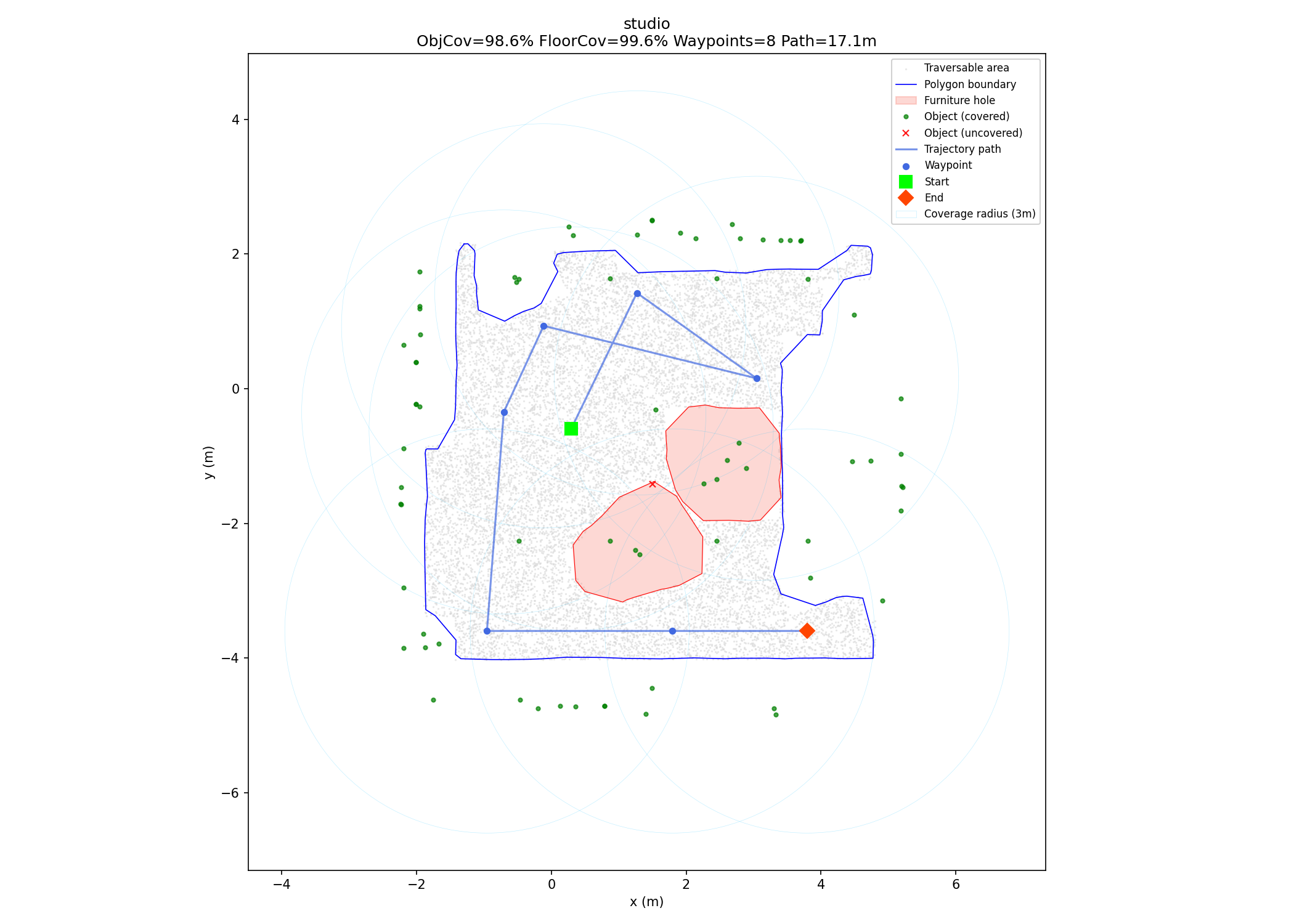
Studio — single room
8 waypoints · 98.6% object coverage · 99.6% floor coverage · 17.1 m path
The studio fits entirely within the 3 m observation radius from a compact set of viewpoints. Only 1 object (object #68, a lamp near the outer wall) is missed because it falls beyond the traversable boundary at a distance > 3 m.
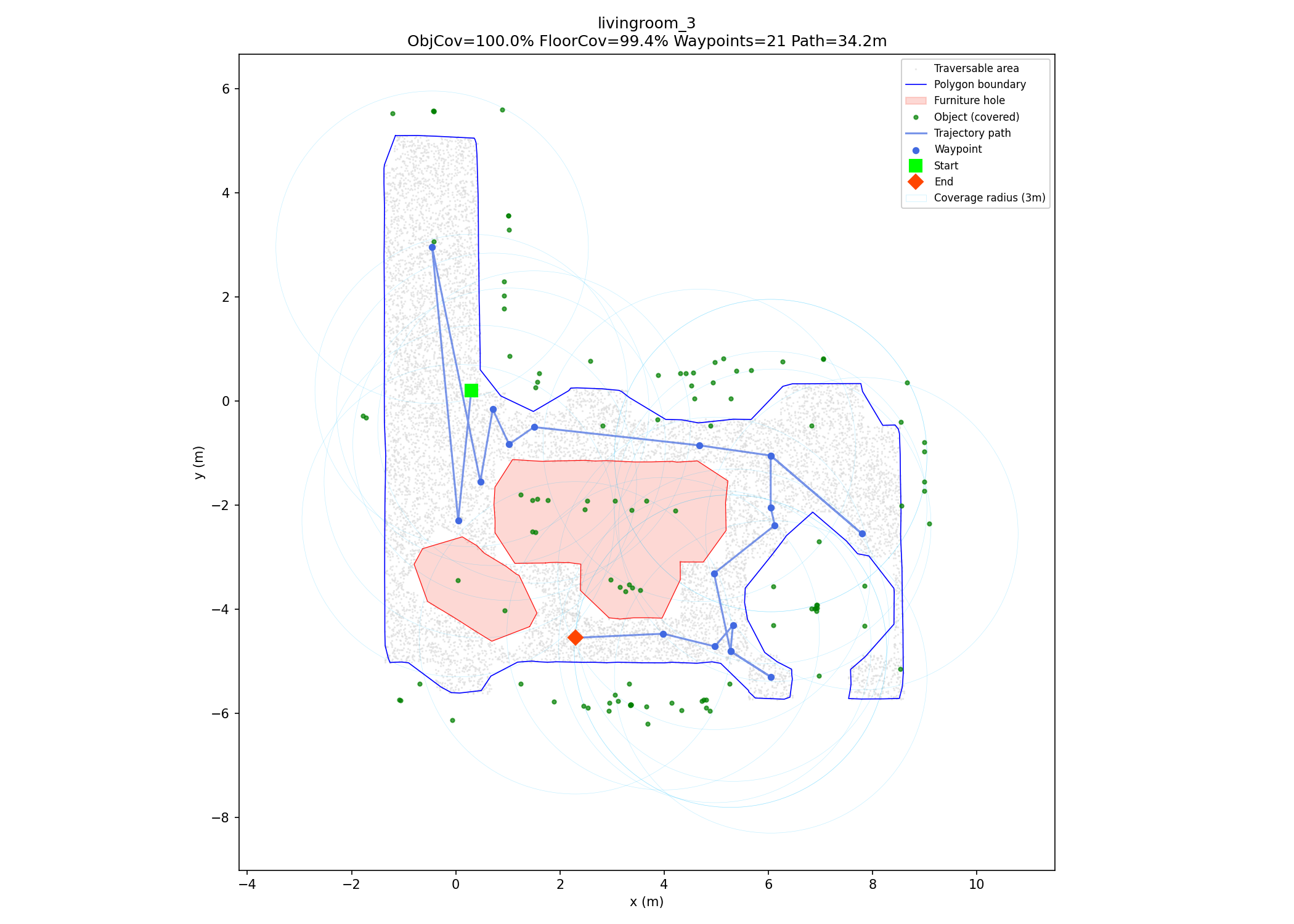
Livingroom 3 — L-shaped room
21 waypoints · 100% object coverage · 99.4% floor coverage · 34.2 m path
The L-shaped floor plan requires the trajectory to turn a corner to reach the second arm of the room. The greedy set cover selects 9 coverage viewpoints; the remaining 12 waypoints are intermediate routing vertices inserted by the visibility graph to navigate around furniture holes.
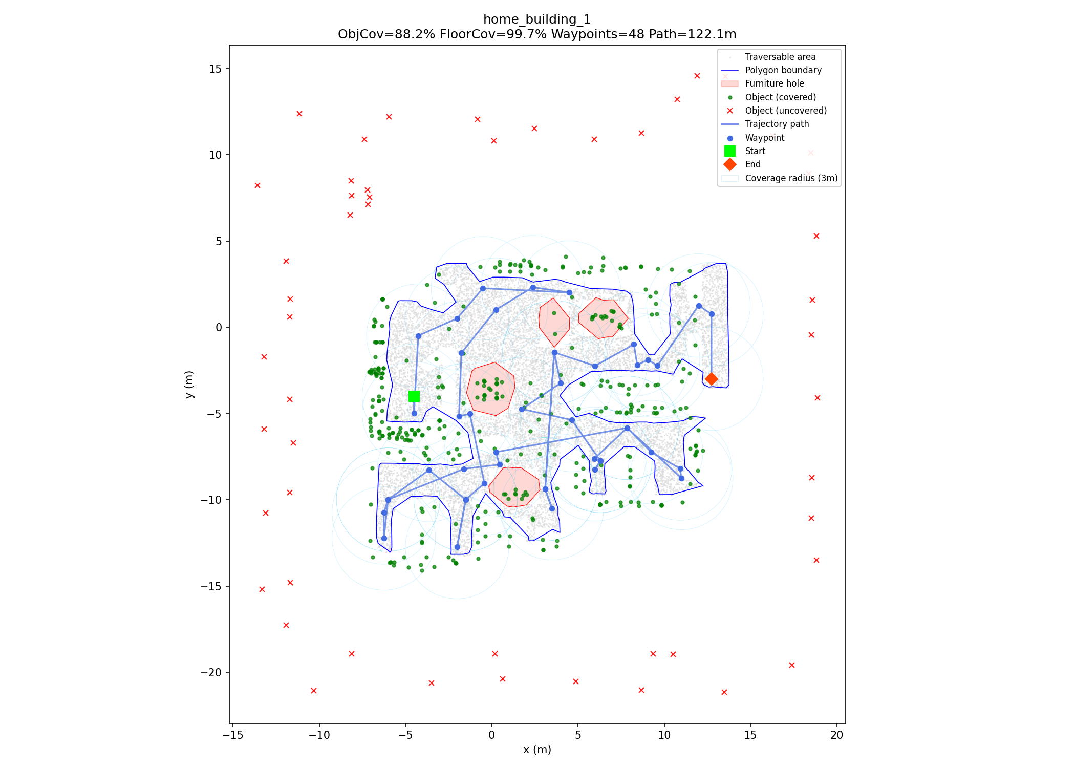
Home Building 1 — multi-room building
48 waypoints · 88.2% object coverage · 99.7% floor coverage · 122.1 m path
The largest scene in the dataset (432 objects, ~122 m path). The 51 uncovered objects (red ×) are outdoor items — trees, gates, and exterior lamps — that are 5–12 m from the walkable area and physically unreachable from inside the building. All indoor objects are covered.
Coverage results
| Scene | Objects | ObjCov% | FloorCov% | Waypoints | Path (m) |
|---|---|---|---|---|---|
| arabic_room | 85 | 97.7% | 97.8% | 12 | 18.3 |
| chinese_room | 96 | 100.0% | 98.8% | 8 | 14.8 |
| home_building_1 | 432 | 88.2% | 99.7% | 48 | 122.1 |
| home_building_2 | 227 | 97.8% | 99.7% | 47 | 103.5 |
| hotel_room_1 | 86 | 97.7% | 99.8% | 16 | 26.4 |
| hotel_room_2 | 95 | 100.0% | 99.6% | 11 | 14.6 |
| japanese_room | 63 | 100.0% | 99.2% | 6 | 9.0 |
| livingroom_1 | 106 | 98.1% | 99.4% | 7 | 11.4 |
| livingroom_2 | 88 | 100.0% | 99.7% | 13 | 25.4 |
| livingroom_3 | 108 | 100.0% | 99.4% | 21 | 34.2 |
| livingroom_4 | 120 | 100.0% | 97.7% | 7 | 10.2 |
| loft | 115 | 94.8% | 98.9% | 9 | 11.5 |
| office_1 | 112 | 100.0% | 97.9% | 12 | 17.2 |
| office_2 | 161 | 100.0% | 100.0% | 12 | 22.0 |
| office_building_1 | 0 | — | 95.5% | 41 | 184.0 |
| office_building_2 | 0 | — | 95.1% | 74 | 330.8 |
| studio | 73 | 98.6% | 99.6% | 8 | 17.1 |
11 of 15 object scenes achieve ≥97.7% object coverage (7 at 100%). All 18 scenes achieve ≥95% floor coverage. Uncovered objects are primarily outdoor items beyond 3 m from the walkable area.
Python API
from pathlib import Path
from xiao_hei_vln.trajectory import plan_trajectory_from_zip

result = plan_trajectory_from_zip(
    Path("scene.zip"),
    scene_name="studio",
    coverage_radius=3.0,
    robot_radius=0.3,
    grid_resolution=0.25,
)

print(f"Object coverage: {result.coverage.object_coverage:.1%}")
print(f"Floor coverage: {result.coverage.floor_coverage:.1%}")
print(f"Waypoints: {len(result.waypoints)}")
print(f"Path length: {result.path_length_m:.1f}m")